Coordinates Tools
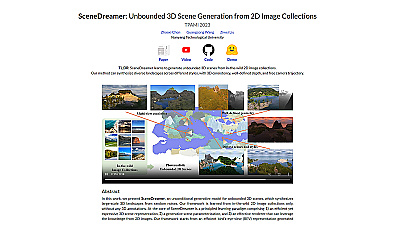
Create immersive 3D landscapes from 2D images effortlessly.

Intuitive map editing with AI-driven insights for all users.
Free
Related Categories
🗺️ Advanced mapping
🗺️ Mapping experience enhancement
🗺️ Mapping features
🗺️ Mapping for cultural heritage
🗺️ Mapping for economic development
🗺️ Mapping for educational purposes
🗺️ Mapping for environmental studies
🗺️ Mapping for humanitarian efforts
🗺️ Mapping for infrastructure planning
🗺️ Mapping for public health
🗺️ Mapping for research projects
🗺️ Mapping for resource management
🗺️ Mapping for transportation
🗺️ Mapping for wildlife conservation
🗺️ Open data projects